|
|
|
||||||||||||
|
|
|
|||
|
|
|
|||
|
Floristic Atlas of the San Juan Islands, Washington
|
The Floristic Atlas of the San Juan Islands provides an easy to use tool for mapping the distributions of vascular plant species within the San Juan Islands, and for analyzing and comparing species distributions and biogeographical patterns. The atlas is based on over 6,700 voucher specimens from the San Juan Islands that are housed at the UW Herbarium as well as observational records from recent surveys of the islands. Included within the atlas dataset are nearly 4,000 specimens from many of the smaller islands collected during comprehensive botanical surveys of the San Juan Islands by the UW Herbarium's David Giblin and The Nature Conservancy's Peter Dunwiddie between 2004 and 2009. Learn more about the San Juans Islands Surveys. |
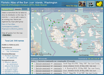
Map comparing the distributions of Sanicula crassicaulis var. crassicaulis (green dots) and Sanicula crassicaulis var. tripartita (red dots) in the San Juan Islands. S. crassicaulis var. crassicaulis is more widespread. Neither variety has yet been documented from the northeastern portion of the islands. |
|
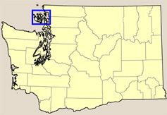
Location of the San Juan Islands in northwestern Washington.
|
Location of the San Juan Islands
The San Juan Islands are positioned between the southern end of the Straight of Georgia and the northern end of Puget Sound, in northwestern Washington about 70 miles northwest of Seattle. This archipelago consists of four large islands accessible by ferry and numerous small islands and islets. The Islands lie within the rain shadow of the Olympic Mountains to the southwest. This rainshadow effect, when combined with exposed rocky headlands and gravelly soils on many of the islands, creates a climate suitable for cacti and other species not normally found in western Washington. About the Atlas
The San Juan Islands Atlas provides a flexible mapping interface that allows you to do more than simply place dots on a static map. Features available through the atlas include:
|
| |
|||
|
|
|
||


